
Ever met a real life descendent of the Eleutherian Adventurers, a sea-faring group of English Puritans who left Bermuda to settle in the Bahamas in the mid-1600’s? We have. Had him onboard twice, including for one of Jennifer’s masterpiece vegetarian lunches. Bandit, as Captain Jock Morgan is also known, traces his ancestry to the days of yore (as does the majority of Spanish Wells residents it seems), when adventurous Bermudans sailed over and then when American colonists loyal to King George traveled here a century and a quarter later during the American Revolutionary War. We learned all that while Bandit piloted us through the imaginatively and aptly named Devil’s Backbone, where many a sailor has perished over the centuries.
Back to the chronology of our travels…need to check the Log Book for this one because it’s been a while. Let’s see. Last we reported, we’d arrived safely in southern Eleuthera after crossing the mile-deep Exuma Sound in near perfect wind and wave conditions (meaning virtually none of either). After anchoring in Rock Sound, in southern Eleuthera, we weighed anchor the following day and headed some thirty nautical miles for Governor’s Harbour, a quaint hillside town with many pretty architectural designs.
A stop-over just wasn’t to be. The sea bottom was mostly grass and the holding for anchoring (even with our 30kg Bruce anchor and 3/8 all chain rode) was very poor. The three guide and chart books we carry for the Bahamas all recommended against picking up one of the mooring balls, as the weighted fixtures aren’t always so, um, fixed into the bottom. Seeing no place to land a dinghy and not another cruising boat anywhere in the harbor helped us to decide to keep motoring.
We traveled another fifteen nautical miles to Hatchet Bay, an anchorage protected against all wind directions. We quickly realized that anchoring there would also be a risky proposition given the poor holding and the abundance of stuff on the sea floor (old mooring weights and lines, sunk trees, etc.) Uh oh, I should have done better planning.
Our chart books did, however, suggest we’d find a few government-maintained mooring balls available free of charge. We did. But, as the saying goes, You get what you pay for… Jennifer and the kids took the dinghy into town and bought some fresh produce and walked the town while I stayed aboard in case our mooring ball line decided to release its tenuous hold to the bottom weight and send us drifting into the high rock walls surrounding the anchorage. Notwithstanding the iffy holding, it was a pretty spot and a charmingly quiet town, and in the end we were well protected from the near 20 knot easterlies that evening.
We learned two things cruising the western coast of Eleuthera. First, we learned it’s a beautiful island with lovely towns, but most the island isn’t set-up to visit by boat. Best to rent a car in a place like Rock Sound and drive north along the beautiful hills, visit the pretty settlements, and admire the calm beauty and colors of the banks and the wide-open ocean views (and surfer’s paradise) of the Atlantic. Second, we learned to listen to the advice seasoned cruisers offer! Cruising friends told us we should see most of Eleuthera by car, not boat. Oops.
Though we missed a few great towns and only saw the Glass Window from afar, we’re still happy to have given it a go aboard Muddy Waters. The crew adapted, and we had a few good day-long runs, one of which included a solo dolphin dancing in front of our boat for fifteen minutes. We also tried to make up for our failure to see much of southern Eleuthera by exploring more of the cruiser-friendly northern tip of the island.
To do that, the morning after spending the night in Hatchet Bay we made a beeline for a cut in northern Eleuthera called The Current. This is the home of what’s reputed to be the world’s best drift dive. I believe it. The Current, appropriately named, is a cut between the large Eleuthera banks and the north side of the island. If you’re traveling off the banks and in a trawler or sailboat, you should travel through The Current at slack tide or an ebb tide (an outgoing tide). Otherwise, you’ll have a heck of a time turning to port from the plotted course (which runs through various coral heads and is perpendicular to the channel) into the cut. And then once in the cut, you’ll have to contend with six knots of current.
Anyway, we arrived just before high tide (and slack water) and decided to poke our nose into the cut (with a bail-out plan just in case). We kept our RPMs low so we could give our single engine (a naturally aspirated CAT 3208, rated at 225 horsepower) some extra juice if needed. We needed it, and how, just to swing the boat to port into the current. Then once in the cut, we pushed our RPMs way up to 2200, worked hard to maintain our compass heading (because the current will catch you and turn you), and crawled our way (at three knots speed over ground) through The Current to the north side of Eleuthera. Phew. We were rewarded with calm, clear, turquoise waters on the other side.
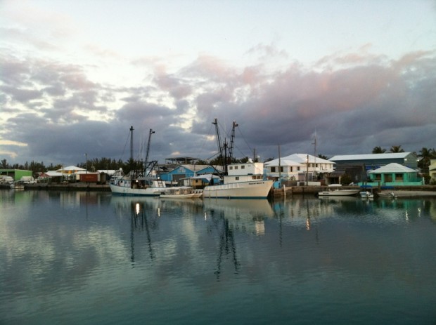
We then made our way to Spanish Wells and called ahead on the VHF to reserve a mooring ball in town since there’s no anchoring room nearby this bustling fishing community. We were lucky to find the one mooring ball that could accommodate a boat our size. We were so close to the beautiful hunter green sailboat next to us, Last Tango, that we called over the rails and said we could hand over a cup of coffee in the morning if they could pass over some sugar… See the photos titled Early Morning Traffic Jam in our March Album. Of course the mooring balls were expertly placed and maintained by experienced watermen so we were in no real danger of bumping. Things were just tight compared to the wide open anchorages and mooring fields of the Exumas.
We spent the day exploring Spanish Wells and thoroughly enjoyed this working settlement of nearly eighteen hundred people, many of whom are descendants of Loyalists who sought refuge here during the Revolutionary War. This couldn’t have seemed anything like the Carolina countryside…
We learned that the majority of the lobster fishing in the Bahamas is based in Spanish Wells. Fishing boats leave town for a month at a time, carrying some three hundred of the island’s men. Those paravanes you see in the fishing boat photos in our March photo album are to steady the boats in rolling seas. Lobstering here isn’t like up in Maine where the lobstermen set traps all along the coastline and collect their traps early mornings. Here, the fisherman don wetsuits and dive down (usually between 15 and 50 feet) to open lobster harvesting areas miles from shore on the Bahamas banks. Like in Maine though, the lobstermen here are careful to only take the mature, and male, lobsters. As a result of carefully managed fishing, their catch has grown consistently over the years and helped Spanish Wells thrive.
We decided we’d next visit nearby Harbour Island, a pretty island famous for its sometimes jet-set crowd and its always pink sand beaches, on the north east side of Eleuthera. But to get there we’d need to traverse the previously mentioned Devil’s Backbone, the dangerous path through house-size coral heads on the open ocean on the northern and northeastern tip of Eleuthera. The locals, and our guidebooks, implore sailors to hire a local pilot to travel across the Devil’s Backbone. This time we decided to take the advice! And we’re glad we did.
Our pilot Bandit, whom we mentioned at the start here, has been plying these waters since 1968 as a captain. He comes aboard and actually takes the helm – whether on a boat our size or a 200-foot tanker. In calm conditions, a pilot will sometimes take the helm of one boat with another one following. In fact, a 194-foot fuel tanker followed us in through the maze of coral reefs, staying in radio contact throughout.
Looking back at the tracks (like a snail trail) we left on our chart plotter, we saw that there’s little margin for error around the coral heads, and that the pounding ocean waves shift the sand almost daily in the sections where there’s no coral. Many ships, large and small, over the centuries have ended up pounded against the rocky shore here. We saw the crushed hull of a thirty-something-footer lying splat on the rocks about half-way through the passage. Yikes.
Bandit was also a colorful character who regaled us with sea stories and lots of local history about Eleuthera, including the story of the Preacher’s Cave and other historical sites (some of which Bandit worked to excavate). If you’re sailing from Spanish Wells to Harbour Islands, hail Bandit on Channel 16 for expert piloting and terrific local knowledge.
Anchored safely on the lee side of Harbour Island, we learned that we could tie up our dinghy at Valentine’s Marina. What luck, as dinghy dock access had been a challenge in Eleuthera, and the sometimes rocky shores made it tough to just leave the dink on the beach. The dock hands and staff at the marina were terrific, and we also got to gawk at the mega-yachts docked at the marina. Keenan took lots of pictures. We were like marine paparazzi.
Jennifer wrote about a place on Harbour Island called South Bar in her Food Blog, so check that out. (I also encourage you to see what’s cooking in her food blog, it’s terrific stuff.) We had a delightful time on the island meeting the family members of a friend from the states. When boating in local waters, local knowledge is always best. And that was certainly the case on land on Harbour Island too. We walked a gorgeous beach, learned the history of the island, saw the mostly pristine southern tip of the island, had lunch at a terrific local restaurant, and generally shared stories and spent time with interesting and lovely people.
We also had fresh conch salad at a stand on the beach one afternoon. So fresh that they shelled the conch right there, chopped it up (Daria wasn’t thrilled perched on a stool in front of the, er, butcher) and add hot peppers, onions, tomatoes, cilantro, and salt. Ummm good. We also rented a gas-powered golf cart and tooled around the entire island, down dirt paths and through each narrow street. Zooming around, the kids found a terrific local bakery. A few of the mornings the kids took the dinghy to shore themselves and walked to the bakery in search of sweet baked goods.
After a few more days anchored off Harbour Island we started to watch the weather more carefully, reading our Chris Parker reports, checking our satellite weather feeds, and checking www.buoyweather.com, www.passageweather.com, www.windfinder.com, and a few other favorite weather sites. A week later we were still waiting for a window to cross to the Abacos, about a 50 nautical mile open ocean journey north and slightly west. With the following week also not looking great for a crossing to the Abacos, we decided to do what good sailors do – we decided to take what the weather would give us.
We called Bandit on the radio and asked if he could take us back across the Devil’s Backbone (about 10 days after we’d come the other way) to Spanish Wells so we could travel west toward Nassau instead of north to the Abacos. While on the way west, in Spanish Wells, we thought about getting a little insurance fuel, but yours truly missed the approach to the fuel dock, and with a strong tail wind and following current couldn’t effectively reverse Muddy Waters in the narrow and busy harbor channel. So with two disappointed dock hands and a few amused fisherman watching, we waved goodbye and ambled westward.
Departing the narrow channel, we moved onto the banks for just a few miles, skirting the outside of the plotted course because of the unusually low tide. We eventually anchored off Meek’s Patch, with the Spanish Wells lights in the distance. We tucked-in close to shore to shield us from the NNE winds that got up near 20 knots that night. We were the only boat within sight, and under a full moon (the closest it had passed by the Earth in 18 years, explaining the super low spring tide!), we had dinner in the aft cockpit (we call it the back porch) and watched another beautiful Bahamas sunset. Just us and the setting sun in the west and the rising full moon in the northeast sky. Just perfect.
The next morning at first light we weighed anchor and headed WSW for Nassau, with following 12-15 knot winds and maybe 3-4 foot seas. A relatively smooth ride of about 40 nautical miles. Through sailors’ luck, we arranged a slip at the Atlantis Marina. We entered Nassau Harbour at an amazingly busy time, with big boats moving in and out and everyone hailing harbor control, local marinas, the fuel dock, local taxis, etc. Once in the marina, we managed to back into our slip smoothly, fooling all the onlookers into thinking we knew just what we were doing. Little did they know.
After nearly three months of anchoring each night, here we are in a fairly fancy pants marina. We’re at the slips that are a bit removed from the main marina basin, which makes our little parking space quiet and just right for us. In the main marina slips, you’ll find a few 200 foot mega-yachts and then some more, uh, moderately sized mega-yachts in the 100 foot range. As the only trawler in town, we still think we have the prettiest boat on the block.
Keenan and Daria have spent two days running around and zipping down all kinds of high-octane water rides. They convinced me and Jennifer to join today, and we have to admit to enjoying the screaming thrill of a long free fall down a water-lined tube that runs through a large aquarium with sharks and other sea creatures. We just kept our eyes closed and tried not to swallow too much water! The aquarium here is also fairly spectacular (see the photos), though surprisingly it lacks placards describing what’s inside the big fish tanks. Thanks to a terrific book called Ocean that Pappy got the kids, they’re quite good at identifying all kinds of sea life.
Though we’re sorry to have missed the Abacos this trip (we’ve sailed there a few times in the past), the two days in Nassau have certainly been fun for the kids. And for us too. Jennifer and I agree this is all a bit of a culture shock (though we did stop at Starbucks and Jamba Juice) after where we’ve been the past few months; but, we’ve also enjoyed watching the kids soak it all in here, with their singular focus on experiencing as many ultra-fast water rides as possible in 48 hours. Maybe this is what happens when you travel at seven knots for three months. Regardless, their smiles say it all. And in a study in contrasts…Jennifer discovered an ashram founded in the 1960s that’s located not far from here, and she’s taken yoga classes and attended a few lectures too.
We’re now watching the forecasts carefully and, weather permitting, hope later this week to travel from Nassau across the Tongue of the Ocean, through the Northwest Channel, and onto the Bahamas banks. We’ll likely anchor on the banks near Russell Light (miles and miles from dry land) before dark and then rise early the next morning and continue on to North Bimini. From there, we’ll watch the weather again and wait for a good window to cross the big bad Gulf Stream back to Florida. That’s today’s plan. Could change tomorrow. And in so many ways, that’s the fun – and even the beauty – of boating.
Michael


very cool — see you all soon!
lv, p
Sounds like such a great time, and good call on enjoying a couple of days at Atlantis since you were in the neighborhood! The only question I had was how teh guide got back home after driving your boat through the coral route?
KEENAN YOUR PHOTOS ARE THE STAR OF THE SHOW. THEY TELL THE STORY SO VERY WELL FOR ANYONE LUCKY ENOUGH TO SEE THEM.
HOPE YOU GUYS HAVE A TERRIFIC RUN HOME . IF YOU GET A CHANCE CALL GARLAND AND JEAN ON THE ARCADIA, I THINK YOU BOTH ARE GOING TO CROSS FROM NASSAU AT THE SAME TIME.
CHEERS TO YOU ALL
I am interested in what Bandit charged to guide you through Devil’s Backbone?
Your blog is excellent!
some awesome pix of jellyfish, ells, etc. in the Atlantis aquarium!!!!
we are having a good time here in the Bahamas!!